You can sponsor this page

Sprattus antipodum (Hector, 1872)

New Zealand blueback sprat
Beobachtung melden im Fish Watcher
Native range | All suitable habitat | Point map | Year 2050
This map was computer-generated and has not yet been reviewed.
Sprattus antipodum   AquaMaps   Data sources: GBIF OBIS
Hochladen Photos und videos
Pictures | Google Bild
Image of Sprattus antipodum (New Zealand blueback sprat)
Sprattus antipodum
Picture by SeaFIC


New Zealand country information

Common names: Kupae, New Zealand herring, Slender sprat
Occurrence: endemic
Salinity: marine
Abundance: | Ref:
Importance: subsistence fisheries | Ref:
Aquaculture: | Ref:
Regulations: | Ref:
Uses: bait: yes;
Comments: Known from the east coast of the North Island, Cook Strait, apparently all coasts of the South Island (Ref. 58461) south to Stewart Island and Foveaux Strait (Ref. 188). Voucher specimen(s) held at the NMNZ. Also Ref. 9258.
National Checklist:
Country Information: https://www.cia.gov/library/publications/resources/the-world-factbook/geos/nz.html
National Fisheries Authority: http://www.fish.govt.nz/
Occurrences: Occurrences Point map
Main Ref: Paulin, C., A. Stewart, C. Roberts and P. McMillan, 1989
National Database:

Common names from other countries

Klassifizierung / Names Namen | Synonyme | Catalog of Fishes(Gattung, Arten) | ITIS | CoL | WoRMS | Cloffa

> Clupeiformes (Herrings) > Clupeidae (Herrings, shads, sardines, menhadens)
Etymology: Sprattus: Old German, sprotte (1611) = a small fish, Clupea sp. (Ref. 45335).

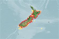
Environment: milieu / climate zone / depth range / distribution range Ökologie


Warning: mysqli::__construct(): (HY000/1040): Too many connections in /var/www/html/includes/func_getlabel.php on line 46
Can't connect to MySQL database (fbapp). Errorcode: Too many connections